Post Your Lighthouses!

The Cedar Point Light originally located on a tiny island off Cedar Point at the southern entrance to Patuxent River was built in 1896. It sat on 1.54 acres with a three-story brick and cedar-shingle house crowned by a 50-foot tower housing lens and fog bell tower, oil house, boathouse, outhouse and barn. A radar reflector now stands in place of the century-old crumbling lighthouse.
01.jpg


Cedar Point Light was made inactive in 1928 and was on the Lighthouse Digest Doomsday List. In 1957 the bell tower collapsed during a storm. The Navy removed the cupola in 1981. The lighthouse was finally demolished in 1996. Portions of the keeper's house were donated to the Calvert Marine Museum. St. Mary's County officials (under the impression that the Navy had given the cupola to them) wanted the lantern for the Piney Point Lighthouse Museum and Park and the Calvert Marine Museum also wanted it. But the Navy felt that it ought to remain near to its original location unless the Commissioners approved a Lexington Park master plan where it would be installed as a historic marker in the Lexington Park Circle which would be close to where it is now.
01041590.jpg

It is still displayed on the grounds of the Patuxent River Naval Air Museum. There are also photos (such as this one) on display in the museum and there is also a diorama of how the lighthouse originally looked.
Lighthouses5.jpg

When I was researching lighthouses of the Chesapeake to make screen paintings of them, I used the photos and reconstruction to paint my picture
 
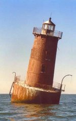
Hooper Island Lighthouse is one of only five lights constructed in the Bay during the 1900’s. It is a caisson style light, sunk 13.5 feet into the muddy bottom of the Bay. It was first lit in 1902. I have only taken one photo of this lighthouse which looks to me a little like a spark plug
Lighthouses6.jpg
11207154.jpg
 
Sharp's Island lighthouse is the third one at this location, south of Tilghman Island.
The first lighthouse was built on Sharps Island in 1838, but due to the island's erosion it was moved in 1848. This was replaced with a screwpile lighthouse in 1866 near the original location of the first structure.

The second lighthouse lasted until 1881 when it was forced off its foundations by an ice floe. It floated nearly five miles down the Chesapeake—with its keepers still inside—until it ran aground, allowing the men to escape unharmed. The current lighthouse was constructed in 1882 is best known today for evoking the Leaning Tower of Pisa, a condition caused by an ice floe in 1977. This was the first lighthouse that I attempted to paint, and I got too much lean in my picture.
x100_7781-001.jpg

It doesn't really lean that much

Screenshot 2025-03-05 022057.jpg
I think I've only been where I could see this lighthouse once, and it was in the middle of a thunderstorm.
 
Last edited:
Another Chesapeake Lighthouse - Sandy Point Shoal Light is a brick three story lighthouse on a caisson foundation that was erected in 1883. It lies about 0.6 mi off Sandy Point, north of the Chesapeake Bay Bridge,
View attachment 11113
I've only seen this lighthouse from a boat and have few photos of it because it is in the north Bay

In Maryland there is a Lighthouse Challenge - in 2019 it was to visit 10 lighthouses and one light ship in two days. Sandy Point (above) was the new "Mandatory" light. I do not have pictures (have not seen) Concord Point, the Lightship Chesapeake, or Fort Washington, but I've already posted Hooper Strait, and Drum Point, and I can do Seven Foot Knoll, Choptank, Cove Point, Piney Point and Point Lookout.
  • Concord Point
  • Seven Foot Knoll
  • Lightship Chesapeake
  • Hooper Strait*
  • Choptank River Replica*
  • Drum Point
  • Cove Point
  • Piney Point
  • Point Lookout
  • Fort Washington
  • Sandy Point Shoal Lighthouse


I'll start with the Choptank River Replica - which I don't have a painting of because I didn't visit it until 2021

Cambridge on the Choptank is on the Eastern Shore of Maryland near the town of Oxford, MD. (Not to be confused with Cambridge, Massachusetts or Cambridge in England which is also near an Oxford)
Choptank River Lighthouse (reconstructed)


Choptank River Lighthouse (reconstructed)
Approaching the Choptank River Lighthouse

Approaching the Choptank River Lighthouse


The tour guide was there waiting. I expected that we would just have a talk on the dock because of Covid, but apparently since they were told that all of us had been vaccinated, they opened the lighthouse for us. And I had also expected that if it was open that I wouldn't be able to go. But there was an elevator.
They had a Fresnel lens inside.
Fresnel lens

Fresnel lens

Fresnel lens demonstration

Fresnel lens demonstration


This is another screwpile lighthouse. The guide said the lighthouse was originally at Cape Charles but that when the lighthouse was pushed over by ice, they picked it up and put it into a warehouse. Then when the Choptank River lighthouse was destroyed, they picked it up from the warehouse and put in in the Choptank River. This lighthouse is a replica built from the original blueprints. He said the St. Michael's lighthouse was due to be destroyed when someone persuaded the man who was taking it apart, not to do that - they paid him more and got a barge from "a rich man in Baltimore" to move it to St. Michael where it was the start of the museum.
 
The tour guide was there waiting. I expected that we would just have a talk on the dock because of Covid, but apparently since they were told that all of us had been vaccinated, they opened the lighthouse for us. And I had also expected that if it was open that I wouldn't be able to go. But there was an elevator.
It seems the stars were aligned just right for you that day, Rosalie! :D
 
In 1999 going north on the Chesapeake Bay
Went past Little Cove Point and anchored inside (south) of Cove Pt. close to shore. Discovered why no one anchors here. Very rolly - up to 20 deg roll (15 deg one way and 5 deg the other) from the wakes of passing barges and freighters. However it got quieter and we were well protected from the North wind.


Cove Point from the 'anchorage'


Cove Point from the 'anchorage'

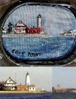
Cove Point Lighthouse was built of locally manufactured brick in 1828. It is visible for 12 miles. By August 16, 1986, Cove Point Lighthouse was officially automated. The new equipment included a fog detector to turn on the horn when visibility dropped below three miles, a lamp-changer in the lantern to change burned out lamps, and a computer to monitor everything. It is now all controlled from Baltimore.

The Calvert Marine Museum acquired the Cove Point Lighthouse. The United States Coast Guard is still responsible for its official operation because this is still an aid-to-navigation. You can get tickets to tour it from the museum, but I have not been successful in doing more than viewing it from a distance.

One of the distinguishing features of Cove Point is the big CNG pier that was built just next to it. So when I painted my picture, I included the pier
Lighthouses8.jpg
 
Last edited:
The Lighthouse Challenge includes places that you can get to by road. Sandy Point can be seen from Sandy Point State Park and from the Chesapeake Bay Bridge (if you are a passenger).

Piney Point is a point of land covered by pines that extends toward the Potomac just upstream of St. George's Island. On this point was build a lighthouse.
2358849-Lighthouse_and_Keepers_House-United_States_of_Americ-1.jpg

I visited Piney Point Lighthouse in 2005 when the tower was open for visitors to climb and they also had boat tours. I didn't include it in my paintings because it is on the Potomac and not the Chesapeake, and also it is a fairly little lighthouse.

100_6965.jpg

This is the photo of it from the Potomac River. In front of the lighthouse are the old Stewart Petroleum plant pipelines and piers where barges of gasoline were brought in and loaded and unloaded. The pipeline runs along the point north of the Piney Point lighthouse, and the access to this area is prohibited.

The Piney Point Lighthouse was built in 1836 by John Donohoo. It is about 14 miles up river from Point Lookout, and it is the oldest light on the Potomac River. Out of 11 lighthouses built on the Potomac, it is one of the four original lights still standing. Several U.S. Presidents, including James Madison, have used Piney Point as a summer retreat.
2103082-Piney_Point_Lighthouse_during_2005_Celebration-Unite-1.jpg

The squat white tower is only 35 feet tall, much the same as the other lighthouses that Donohoo built, such as Concord Point and Cove Point. The wall at ground level is four feet thick.

Just below the lantern floor, the interior is about seven feet in diameter and the walls are 18 inches thick. The original lighting apparatus consisted of 10 lamps with each in its own 15-inch reflector. In June of 1855 this was replaced with a 5th-order Fresnel lens which has since been removed.
2358848-Lighthouse_through_the_Keepers_House_window-United_S.jpg

Lighthouse from inside the Keeper's House which is now a museum

The light was decommissioned in 1964 and in 1980 the Coast Guard transferred ownership to the Saint Mary’s County Department of Recreation and Parks. The grounds were flooded during 2 hurricanes in the late 1990's, and again by Hurricane Isabel in 2003.

The restored tower steps allow visitors a bird's-eye view of the area during the Annual Piney Point Celebration held in May.
2358854-Looking_up_from_below-United_States_of_America.jpg

Originally I thought I would not climb the lighthouse. I could have done so as it was open to climb. However the space inside at the top is limited. By the time I changed my mind about it, there was a long line waiting (photo 3). So I went to stand in line, but it was too long for me to stand. They let me sit at the bottom of the tower and I took a picture looking up. Then Bob was getting impatient, so I left before I got to climb and went home.
 
Last edited:
Screenshot 2025-03-06 140356.jpg

There is more to Piney Point than just the lighthouse, including a marker in the river which shows where a submarine was sunk.
Screenshot 2025-03-06 140112.jpg

The Lighthouse Keeper's house was built at the same time as the lighthouse (by the same builder) in 1836. Originally it was a one story building with a central fireplace

Screenshot 2025-03-06 140145.jpg
and a ground level basement. The building has been greatly modified through the years. In 1884, a full second story and the porches were added, and new windows were installed.

The Keeper’s Quarters are now a private residence for security and grounds keeping purposes, but during the annual open house in 2005, the house was vacant (and empty) so we could tour it.
Screenshot 2025-03-06 140027.jpg

Lighthouse Keepers

* 1836 Philip Clark
* 1840 Henry C. Heard
* 1845 Charlotte Suter
* 1846 William B. Taylor
* 1849 John N. Nuthall
* 1850 Martha Nuthall
* 1861 Robert Marshall
* 1865 Henry Steinhise
* 1869 Noah Wilson
* 1873 Elizabeth Wilson
* 1877 Helen Tune
* 1883 Thomas W. Costin
* 1910 George Costin
* 1910 William Slacum
* 1911 Loch Humphries
* 1910 William Yeatman
* 1931 William Goeshy

!n 1880, a bell tower was built next to the lighthouse. Bells were used as a warning in fog when mariners might not be able to see the light. The bell was replaced in 1936 with a reed horn (foghorn). The tower was severely damaged in a storm, and afterwards was dismantled, although the outline can still be seen on the west side of the lighthouse.
Screenshot 2025-03-06 141333.jpg


Screenshot 2025-03-06 135838.jpg
 
Back
Top Bottom